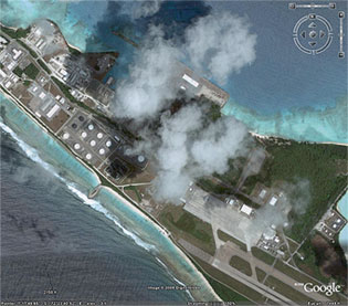
 I was looking through my old blog entries today and discovered that the good folks at Google Earth have added high-resolution images of Diego Garcia. Check it out! Have a look around – you can clearly see the well-stocked ships in the lagoon, B-52’s on the tarmac, the (nuclear?) weapons storage bunkers and if you click this link, you will fly directly to the barracks I lived in for a year. I was on the lagoon side – as you can see, just a few feet from the Indian Ocean. I fell asleep to the sound of gentle ocean waves every night. Fantastic!
I’ll let you know when they finally add high-resolution imagery of Thule, Greenland.
Hi! Great site you have I am very interested of Diego Garcia. I first found the Island at Google Eart (!), the I decided to found out more about the great island. It looks like a paradise!! But, how to get there? It´s not so easy to sail in to the island with a yacht, they say. You will be stopped. But can I visit the island at any other way? Hope you know, because you worked/lived there, because I don´t!
Thank you, Philippo
Hello dude! Nice pictures indeed Diego Garcia looks like a paradise. I found out about the island from wikipedia. I was a little sad to hear of its’ history before the 70’s: http://en.wikipedia.org/wiki/Depopulation_of_Diego_Garcia I can’t blame you for wanting to live there after Greenland though!
Interestingly, no one ever spoke of any earlier inhabitants of this little island. It was easy for me to assume, naively, that no humans had ever lived on this few square miles of paradise. Wrong.
I was there for about 3 months in 2005 during the summer. It was a nice island, those are also portable ‘docks” for the b-2s.
MY SON IS STATIONED ON THIS BEAUTIFUL ISLAND. I’VE ENJOYED LOOKING AT THIS SITE AS IT HAS ALLOWED ME TO GET A GOOD VISUAL IN MY MIND–BETTER THAN THE MOUNTAINS WITH AL QUADA!! THANK YOU FOR SHARING THIS SITE. A US NAVY MOM